
First, to get ourselves oriented. We just left the checkpoint where the big red X is. We are heading north along the blue road that heads strait off the map above. On the right is Har Homa and on the left. Hi’vat Hamatos. That little brown blob to the right of Har Homa is the Church. I’ve outlined in black the places where pictures were taken, and sites of main interest.


There are some interesting “ruins” around the site, so a wide wander was arranged. There’s a lot lot absorb, and its a bit of a long post, but let me whet your appetite with the promise of a settler family living in an old Egged bus, Jordanian-era barracks next to a church, and Byzantine artifacts you could picnic on if you felt like eating next to the newly-routed highway.
Yallah, we photo tour:
All along the left side of the road are remnants of what appear to be some sort of production complex, with building shapes i’d never seen before. Apparently it was once used to produce lime, i think to make mortar, but correct me if I’m wrong.
Wandering along the south/east hilltop, you see exciting things like:
 |
| Water reservoir |
 |
| Triangle-roofed building |
 |
| Gutters? |
 |
| Cistern? |
 |
| And a…. a what? |
C’est qua ca, you ask? Ok, maybe you didn’t, because I already said it was a Lime Kiln, but we didn’t know that at the time.
So, obviously, further inspection was necessary.
The building was a quarter buried, but didn’t have any windows.

Down the hill of dirt and rubble, one finds:

Looked like an oven to me.
Complete with smoke damage.


And lizzzzzard eggs. cool.

Up top was a round hole that could be none other than a chimney.
The buildings all round were – people who live here tell me – destroyed/damaged during the 1967 war, when Israel took over the West Bank from Jordanian control following a 6-day-long war against the neighboring Arab nations.
Here’s where its interesting:
This was the Green Line. The real, internationally recognized boundary between the West Bank and Israel. (yes, the wall and the checkpoint are about a kilometer East down the road. that for another day)
And just to punctuate the moment, lets ruminate on this olive tree, which knows its on the border. Get it?

How can we tell we are on the border you ask? Jordanian-era trenches, that’s how.
Yup, go on a walk to the monastery, find trenches.

Inside the trenches:

Apparently (this has yet to be verified – give me a few weeks) there are tunnels that lead from these trenches, to….
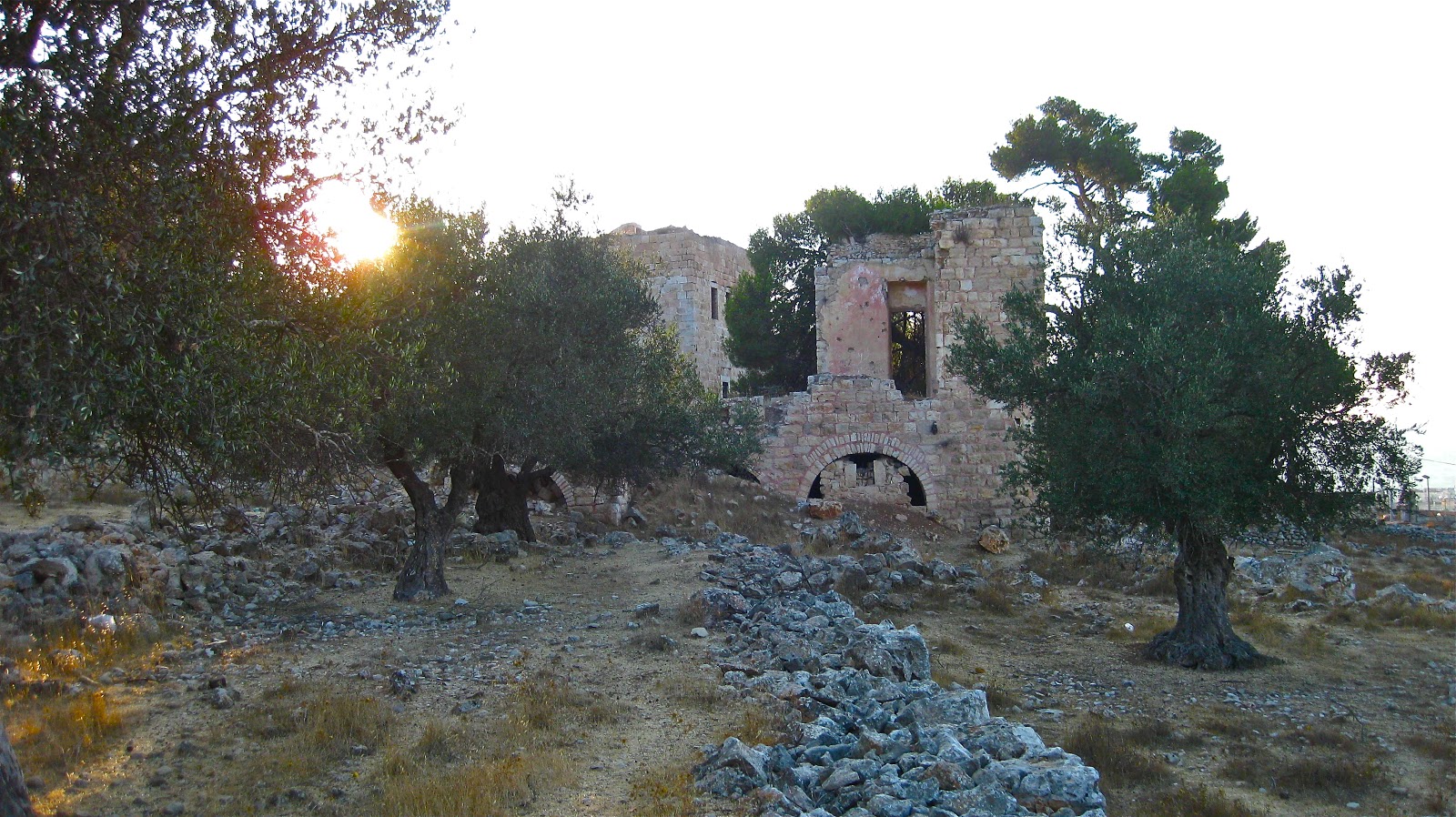
The headquarters, apparently built much later, stationed on the far side of the hill just next to the monastery.

More about this in a sec. I just can’t leave out the best part of the other side of the hill.
Behind the Lime Kiln, and west of the Jordanian-era trenches. There was……

A settlement?
And yes, that is a water tank on top of a bus, and yes, there is a family that lives inside the bus. Don’t worry, the fridge and the freezer are outside, so there is plenty of room for the four children we saw hanging out.
If you refer back to the map, you can find this under the purple area labled Gi’vat HaMatos.

There is regular Egged Bus service to this community. Though I’m not sure it stops at the stations. As we wandered through, at least three buses made the rounds, so during the day there is a bus to this area every 8ish minutes.
Again, just to recap so far:
This is an Israeli family that lives in a bus on the Palestine-side of the Green Line near a monastery, beside a Lime Kiln that was destroyed in 1967 during fighting that lead to Israel’s occupation of the West Bank, which is why there are trenches next to the community of about 75 trailers, each which have satellite dishes and new cars parked outside.
Here’s a close-up of the bus/house.

The shepherds we asked (because of course there were shepherds) said that the community had been there for ten years, and that the folks that lived there didn’t want houses. According to other informed sources, ten years ago this area was inhabited almost solely by Ethiopian Jews who immigrated to Israel.
Anecdotal evidence suggests that there are no Ethiopians there now. All the folks I saw were pretty pale for Ethiopians.
Ok, if you’re mind is not boggled and you have some procrastination time left, keep walking past the settlement/community/bus dwellers, and down the hill toward the entrance to Beit Safafa, a Palestinian neighborhood that has been illegally annexed into Israel’s “greater Jerusalem.”
Here we have what I’m told is a school. Was a school. Notice the greenery growing out of the roof.
Upon closer inspection, one also marks the bullet holes inside. Apparently the roof collapsed during the fighting in 1967.


And just in case you were wondering. Nasser was here too. Well before I was:
Wow, the fun never stops.
Because across the road, back toward the monastery….. There are the ruins of a Byzantine church!!!

What the frick you say? How can there be so many things all so close together? I know. I couldn’t just keep all this to myself.
Apparently, this was excavated when they re-routed Hebron Road (it used to wind and passed much closer to Mar Elias).
There are columns and a pool for collecting water. Apparently sooome day this will be made into a tourist attraction, but I guess for now no one is so concerned? Funny what becomes important and what doesn’t.
If you continue east from the Byzantine church and through an olive grove, you get back to Mar Elias.

A rather modest church, with walls lined with canvas, onto which frescos of saints and things are painted. First time I’d seen the painting done on canvas and then wallpapered onto the stone. More efficient I suppose.
The monastery is home to one priest. No one else stays there, but there is an old lady who sells souvenirs and a restaurant open from 8-4 which feeds pilgrims, for a price.

A group from Greece came in while we were visiting the church. They were *just* here for lunch though. About five percent of the bus tour actually went into the church.
Besides the priest and the resto, there’s this guy:

He is in a glass coffin with plastic flowers glued to it. I have no idea who he/she is.
Ok, phew. Almost done here.
We just need to exit the monastery, head to the Jordanian military headquarters then we can go home.


So take one last look at the trenches. With Har Homa in the background.
(note, that both Gi’vat HaMatos and Har Homa are illegal settlements built on occupied land. If the shepherds are to be believed, the residents of the former just don’t want stone homes….)
And this sign spray-painted onto the outside of the barracks saying that it had been declared under Israeli control (we think… let me know if you can read it better) and that you shouldn’t enter.
Then turn around and take one last look at the sun setting behind the monastery.


nice photos, I like the feeling of walking through all this along with your narrative.
LikeLike